The Map View Tool can be used either for marking locations on a (Google) map,
usually for the purpose of obtaining latitude/longitude values, or
for displaying locations related to an eBird search.
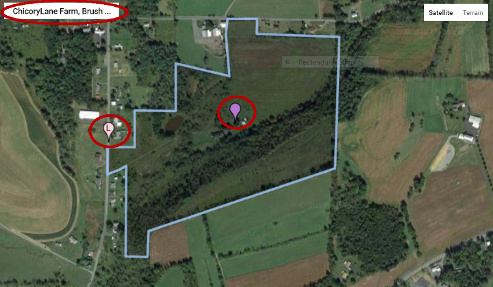
This page describes input functions, using the image below as reference.
(A subsequent page will describe display functions.)
Geographic Browsing
Based on the Google's Maps API, the ChicoryLane eBird Map Tool can be used to view any geographic location
anywhere in the world! The location shown above is in Penns Valley in central Pennsylvania, specifically
ChicoryLane Farm near Spring Mills, PA. The boundaries of the farm are outlined in this image, but
no such marking
will be seen elsewhere and it will be ignored in this discussion.
To view and perhaps mark a different location, the user can either manually pan and zoom the view or
move directly to a specified location through Google's Places function. Two controls
manually shift the view. Zoom is provided by + and - marked controls in the lower right corner of the Map display
but are not visible in this screen shot. They are used conventionally to zoom in and out vertically.
To pan horizontally, the user may click on the map and drag to "pull" the map's view to another location.
Whereas the manual controls are essential for fine-grain adjustments to position, they don't work well
for navigation to a distant location. To move to a "known" location, one can use Google Place function, shown in the marked area
in the upper left corner of the screen image. There, one may enter an address; the name of a town, county, state, etc.; as well
as other named locations - in this example, ChicoryLane Farm which is included in Google's database of places. When
information is being typed into the Places field, Google applies its typing completion algorithm such that one can stop entry and select
an intended place name, once it is supplied by Google.
Mark Locations
A main purpose for navigating in the Map Tool is to identify the location at which to center a search.
Thus, one needs to mark such a location so that its latitude and longitude can be recorded. This is done by creating a marker on the
map. Two markers are visible on the map above: the pink marker on the left with a label "L" (for location) and the lavender
marker near the center. The L-marker is created automatically when a location is found using the Places function; the
lavender marker is created by the user's simply clicking on the map at the intended point. Either marker can be dragged
to a new location or deleted by right-clicking on it. If more than one marker has been created, all may be deleted by
right-clicking on the map and selecting the "remove all" option from a popup menu.
One consequence of creating a marker - perhaps its main justification - is that its latitude and longitude are automatically noted
by the Map Tool and automatically made available to the Search Tool for entry into the search form included there. More
specifically, the latitude and longitude values that are passed to the Search Tools are those for the last marker
created, selected, or dragged. Use of the ported positional values will be explained in the Search Tool description.
Wrap-up
This discussion has focused on using the Map Tool to generate latitude and longitude values for "seeding" a
recent sightings search. It can also provide a geographic view of an area subsequently searched as well as locations where
any sightings found in that area appear. Both of those uses are likely to follow a Search operation, discussed in
a linked page, accessible below. Another use for the Map tool during input prior to a search is to visualize the specified
search area before actually performing the search. This is done by porting information entered into the Search Tool
back to the Map Tool and will be explained in the discussion of the Search Tool.